2 min read
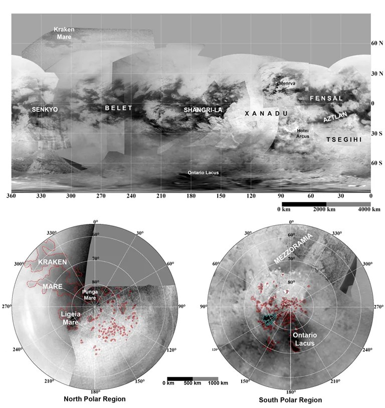
A RADAR swath swept across the northwest Shangri-La dune fields in Titan's southern hemisphere during the May 21, 2009 flyby.
The Ion and Neutral Mass Spectrometer (INMS) performed measurements at the same time as RADAR, obtaining unique nightside coverage at low Southern latitudes. This provided coverage for the outer flank of the magnetospheric interaction region.
Cassini encountered Titan at an altitude of 965 kilometers, traveling at a speed of 6.0 km/sec. Closest approach occurred at 03:42 PM PDT, latitude 22 degrees S. RADAR was the prime instrument and directed spacecraft pointing during much of this flyby. The instrument performed observations involving scatterometry, altimetry, and synthetic aperture RADAR (SAR). The SAR observation occurred over the southern hemisphere with the instrument sweeping across the NW Shangri-La dune fields and into high southern latitudes.
The Ion and Neutral Mass Spectrometer (INMS) rode along with RADAR and obtained night side coverage at low southern latitudes. This flyby provided a unique opportunity for INMS, allowing coverage for the outer flank of the magnetospheric interaction region.
On the inbound leg, the phase angle was much larger than 90 degrees. This provided an opportunity for the Visual and Infrared Mapping Spectrometer (VIMS) to ride along and obtain information on Titan's atmosphere composition. After closest approach, VIMS rode along with CIRS. While CIRS obtained data for composition integrations and stratospheric temperature maps, VIMS observed the south polar region and obtained cloud-monitoring data.
The Ultraviolet Imaging Spectrograph (UVIS) obtained an image cube of Titan's atmosphere at Extreme Ultraviolet and Far Ultraviolet wavelengths. These cubes provide spectral and spatial information on nitrogen emissions, H emission and absorption, absorption by simple hydrocarbons, and the scattering properties of haze aerosols. This is one of many such cubes gathered over the course of the mission to provide latitude and seasonal coverage of Titan's middle atmosphere and stratosphere.
The Magnetospheric Imaging Instrument (MIMI) measured energetic ion and electron energy input to Titan¹s atmosphere, and Radio and Plasma Wave Science (RPWS) measured thermal plasmas in Titan's ionosphere and surrounding environment, searched for lightning in Titan's atmosphere, and investigated the interaction of Titan with Saturn's magnetosphere.
Date
May 21, 2016
Altitude
599 miles (965 km)
Speed
13,400 mph (6.0 km/sec)

